SETI
STAR MAPS

Maps .. SETI Home Page

 
The Celestial Coordinate System


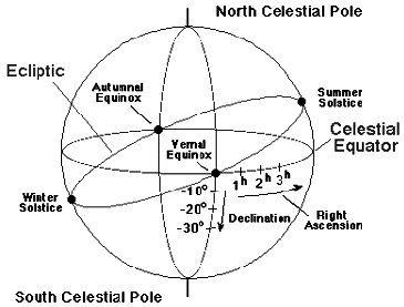
Right Ascension and Declination

In the celestial coordinate system the North and South Celestial Poles are determined by projecting the rotation axis of the Earth to intersect the celestial sphere, which in turn defines a Celestial Equator. The celestial equivalent of latitude is called declination and is measured in degrees North (positive numbers) or South
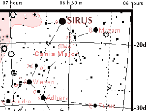
 (negative numbers) of the
Celestial Equator. The celestial equivalent of longitude is called right ascension. Right ascension can be measured in degrees, but it is more common to measure it in time (hours, minutes, seconds): the sky turns 360 degrees in 24 hours and therefore it must turn 15 degrees every hour; thus, 1 hour of right ascension is equivalent to 15 degrees of (apparent) sky rotation. 


Equinoxes and Solstices

The zero point for celestial longitude (that is, for right ascension) is the Vernal Equinox, which is that intersection of the ecliptic and the celestial equator near where the Sun is located in the Northern Hemisphere Spring. The other intersection of the Celestial Equator and the Ecliptic is termed the Autumnal Equinox. When the Sun is at one of the equinoxes the lengths of day and night are equivalent (equinox derives from a root meaning "equal night"). The time of the Vernal Equinox is typically about March 21 and ofthe Autumnal Equinox about September 22.

The point on the ecliptic where the Sun is most north of the celestial equator is termed the Summer Solstice and the point where it is most south of the celestial equator is termed the Winter Solstice. In the Northern Hemisphere the hours of daylight are longest when the Sun is near the Summer Solstice (around June 22) and shortest when the Sun is near the Winter Solstice (around December 22).

The opposite is true in the Southern Hemisphere. The term solstice  means to "stand still"; at the solstices the Sun reaches its most northern or most southern position in the sky and begins to move back toward the celestial equator. Thus, it "stands still" with respect to its apparent North-South drift on the celestial sphere at that time.

Traditionally, Northern Hemisphere Spring and Fall begin at the times of the corresponding equinoxes, while Northern Hemisphere Winter and Summer begin at the corresponding solstices. In the Southern Hemisphere, the seasons are reversed


Coordinates on the Celestial Sphere

The right ascension (R.A.) and declination (dec) of an object on the celestial sphere specify its position uniquely, just as the latitude and longitude of an object on the Earth's surface define a unique location. Thus, for example, the star Sirius has celestial coordinates 6 hr 45 min R.A. and -16 degrees 43 minutes declination


This informs us that when the vernal equinox is on our celestial meridian, it will be 6 hours and 45 minutes before Sirius crosses our celestial meridian, and also that Sirius is a little more than 16 degrees South of the Celestial Equator.


Keeping your Perspective

Do not become confused because the perspectives in the celestial sphere diagram (top) and the sky segment diagram containing Sirius are different. In the celestial sphere diagram one is imagining an outside view of the celestial sphere .  In the diagram above showing the position of Sirius in the sky the view is instead the actual sky as viewed from the Earth (that is, from the center of the sphere in the first diagram).
  Thus, the directions get reversed: moving to the right from the vernal equinox in the first diagram will look like moving to the left as viewed from its center, which is the perspective of the second diagram (that is, the actual view of the sky from Earth). That direction,  is chosen to be the positive direction for right ascension. 


ON ALL 68 MAPS PROVIDED 
RIGHT ASCENSION FROM ONE HOUR TO THE NEXT
IS MEASURED IN 5 MINUTE INCREMENTS.
DECLINATION IS MEASURED BY 1 DEGREE INCREMENTS
Coordinates listed are for center of each map
Use the coordinates displayed under Data Info
then locate the map with the closest position.


THE STAR MAPS
THE CONSTELLATIONS
RIGHT ASCENSION
DECLINATION
Andromeda
00h 32m
+38d 32'
Antlia
10h 10m
-38d 26'
Apus
16h 10m
-76d 17'
Aquarius
22h 43m
-10d 11'
Aquila 
19h 40m
-02d 30'
Ara 
17h 23m
-53d 35'
Auriga
06h 00m
+41d 44'
Boötes
14h 44m
+30d 43'
Camelopardalis
05h 46m
+70d 16'
Cancer 
08h 41m
+20d 09'
Canes Venatici
13h 10m
+41d 09'
Canis Major
06h 52m
-21d 59'
Capricornus
21h 01m
-20d 14'
Carina
08h 46m
-59d 53'
Cassiopeia
01h 01m
+62d 12'
Centaurus
13h 08m
-45d 58'
Cepheus
22h 31m
+71d 35'
Cetus
01h 25m
-11d 21'
Chamaeleon
10h 35m
-79d 45'
Circinus
15h 05m
-59d 01'
Columba
05h 46m
-35d 17'
Coma Berenices
12h 46m
+21d 50'
Corona Australis
18h 38m
-41d 29'
Corvus
12h 28m
-13d 20'
Crux
12h 27m
-59d 58'
Cygnus
20h 27m
+42d 02'
Delphinus
20h 42m
+13d 49'
Dorado
05h 14m
-63d 42'
Draco
17h 45m
+62d 31'
Eridanus
03h 15m
-45d 49'
Fornax
02h 47m
-31d 38'
Gemini
07h 11m
+22d 41'
Hercules
17h 20m
+29d 59'
Horologium
03h 07m
-52d 48'
Hydra
12h 52m
-35d 48'
Lacerta
22h 28m
+44d 49'
Leo 
10h 40m
+16d 27'
Leo Minor
10h 18m
+35d 10'
Lepus
05h 35m
-19d 19'
Lupus
15h 24m
-42d 58'
Lynx
08h 02m
+45d 19'
Lyra
18h 50m
+36d 49'
Monoceros
07h 09m
-05d 44'
Musca
12h 20m
-70d 20'
Norma
16h 03m
-52d 01'
Ophiuchus
17h 11m
-04d 14'
Orion
05h 35m
+04d 35'
Pavo
19h 41m
-66d 08'
Pegasus
22h 45m
+19d 32'
Perseus
03h 43m
+41d 46'
Pisces
00h 31m
+11d 05'
Puppis
07h 34m
-39d 23'
Pyxis
08h 58m
-31d 02'
Sagitta
19h 54m
+18d 47'
Sagittarius
19h 47m
-20d 46'
Sculptor
00h 30m
-32d 21'
Scorpius
16h 59m
-37d 10'
Scutum 
18h 40m
-10d 18'
Serpens
17h 11m
-04d 14'
Sextans
10h 16m
-02d 25'
Taurus
04h 46m
+18d 52'
Triangulum
02h 07m
+32d 02'
Triangulum Australe
16h 05m
-65d 55'
Tucana
00h 08m
-64d 58'
Ursa Major
11h 10m
+55d 23'
Vela
09h 41m
-47d 27'
Virgo 
13h 13m
-03d 44'
Vulpecula
20h 20m
+25d 04'